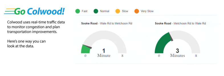
A glimpse at the data Colwood uses to manage traffic flow and plan road improvements. It can also help you plan your drive through Colwood using real time traffic data.
The Colwood Traffic Dashboard shows the real-time, reliable traffic information that allows the City to monitor congestion and take action as needed to improve traffic flow.
It’s not intended to replace Google or Apple maps but is one practical way to demonstrate to residents that the City is using data to drive transportation planning. So for example, it’s one way to quickly compare whether it will be faster to take Sooke Road or Veterans Memorial to get to Highway 1 on your morning commute. But more importantly, the City can use this driving data combined and compared with pedestrian, cycling and BC Transit onboarding and offboarding data to track mode shift over time as improvements are made to the City’s road, transit, pedestrian and trail networks.
"The Colwood Traffic Dashboard gives people access to information about traffic congestion and travel times on specific routes in Colwood," said Colwood Mayor Rob Martin. "Drivers can use the information to decide the best times to travel and which route to take, and it will expand the City's transportation planning capabilities for everything from adjusting traffic signal timing, to planning road, sidewalk and transit improvements."
How is the data gathered?
The system tags anonymous Bluetooth signals from cell phones and in-car systems to calculate the average speed and time it takes vehicles to travel between various detection points in the city. The data can also be trended over time to monitor change, and be combined with transit, pedestrian and cycling data to further inform transportation planning in the City.
This is just one way Colwood uses data driven transportation planning to improve how we move. Learn about other initiatives at www.colwood.ca/GoColwood