Nestled along more than 7 kilometers of breathtaking oceanfront and set amongst some of the most beautiful parks and trails on Southern Vancouver Island, Colwood is a fantastic place for your new business.
The City is poised for significant growth and change with new development land available that is suitable for Light Industrial Uses.
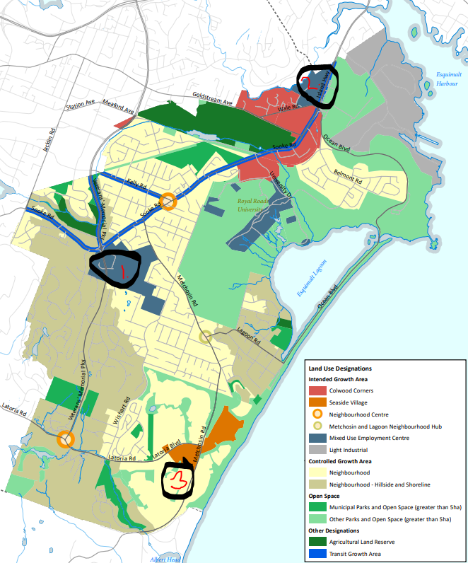
Three key light industrial areas
The map adn details below describe the location of three areas in Colwood that may be suitable for your Light Industrial or Warehousing uses and generally reflect the Mixed Use Employment Centre in the Official Community Plan:
- Allandale District
- Island Highway
- Royal Bay
Note that Colwood's OCP includes design guidelines for the Mixed Use Employment Centre with very strong emphasis on integrating these uses into the community:
- Limited parking between the building and the road right of way by locating buildings close to street frontage
- Pedestrian scale built form and public areas
- Significant landscaping to screen outdoor storage and buffering between uses
- Avoidance of large parking areas; Parking to be located underground or behind building
- Circulation to be focused on pedestrians and cyclists over vehicles
- Avoid use of chain link fencing
1. Allandale District - Sooke Road and Veterans Memorial Parkway
The vision for this area is a Mixed Use Employment Centre for a range of light industrial, commercial, and residential uses.
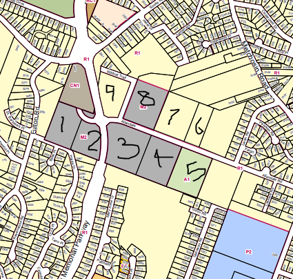
- #1 BP application in works for warehousing
- #2 (681 Allandale Road) is zoned MUEC1 which enables mini-storage and a range of commercial retail uses.
- #3 (651 Allandale Road) and #4 are zoned M2 which enables a range of industrial uses and include warehousing.
- #5 is zoned A1 (Rural Residential) but could consider rezoning to enable light industrial uses but sensitive to surrounding residential uses – would want to see transition between uses.
- #6 and #7 are R1 (Residential) but could consider rezoning to enable light industrial uses but sensitive to surrounding residential
- #8 (650 Allandale Road) is zoned MUEC2 which enables a range of uses from light industrial, warehousing, and commercial uses
- #9 is R1 (Residential) but could consider rezoning to enable light industrial uses or other uses enabled within the Mixed Use Employment Centre Land Use Designation.
2. Island Highway Corridor - bordered by Wale Road and Wilfert Road
The vision for the Island Highway Corridor is a Mixed Use Employment Centre for a range of light industrial, commercial, and residential uses.
1764 Island Highway is currently undergoing the rezoning process to the MUEC2 Zone to enable warehousing and light industrial mixed uses with commercial retail – this would be further encouraged to align the zoning with the Mixed Use Employment Centre Land Use Designation in the OCP.
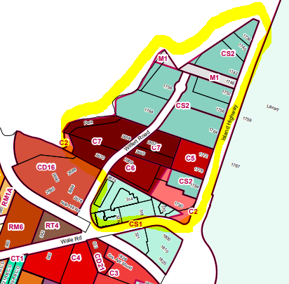
- M1 zone (light grey) enables light industrial
- CS2 (Service Commercial) Zone enables warehousing
- C5 does not enable industrial or warehouse uses (generally commercial and residential)
- C2 Similar to C5 Uses
- C7 enables light manufacturing and storage (not specifically warehousing) and other residential and commercial uses
- CS1 enables retail lumber and building supply with unenclosed storage
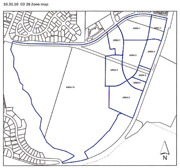
3. Royal Bay - Latoria Boulevard and Metchosin Road
The area south of Latoria Boulevard was recently rezoned to a Comprehensive Development Zone. Warehousing uses would be permitted in Area 5 below. This is limited light industrial including testing, servicing, and repair but excludes manufacturing, processing or assembly.